Warm Front Rider Supercell
March 18, 2021
North-Central North Carolina
This chase day was a rare combination of robust atmospheric conditions, widespread beautiful storms, and perfect positions by our storm chasing teams across the region. Dozens of up and coming chasers targeted North Carolina with great success on Thursday, March 18, but this post will focus on one storm in particular. The warm front riding HP supercell provided an exceptional look at storm structure and environment, and we bagged one confirmed tornado and several other possible (but unconfirmed) touchdowns.
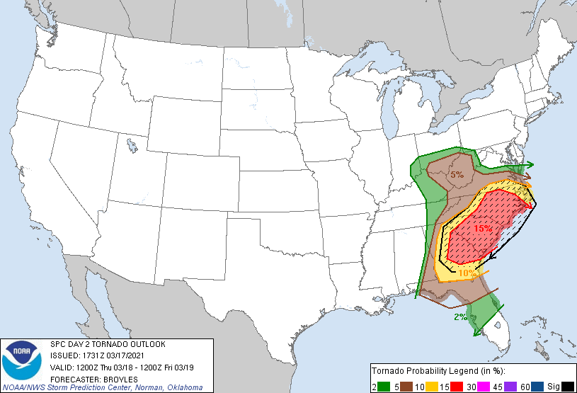
The Storm Prediction Center kicked things off with a Day 2 moderate storm outlook with a 15% hatched area for the potential of "multiple significant tornadoes" across the Carolinas. This outlook genuinely surprised us, but appeared to be justified by the high risk outlook in the Deep South the day before.
However, as the event in the Deep South unfolded and the storms drew closer on the day of the chase, it became clear that this forecast was overkill. The convection allowing models showed very poor thermodynamics in the moderate area and struggled to develop deep convection at all. It became evident that the corridor of severe weather would likely be much more limited than initially thought, perhaps limited to just one or two regions in the Carolinas.
This was finally reflected in the Day 1 16:30z SPC update which completely removed the moderate risk, and reduced the tornado outlook to a narrow corridor of 10% hatched in Central North Carolina. By this time, we were already in position just north of Greensboro, North Carolina on the warm front, and in perfect position to chase this highlighted area. Careful forecasting and positioning had placed us on the southern edge of the CAD wedge, and we parked less than 10 miles south of the cold air in the warm sector.
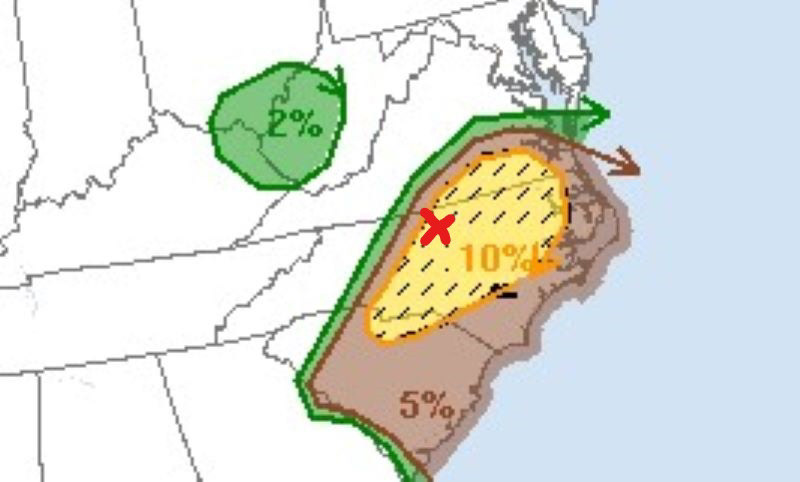
Our position at 4pm for the SPC update (above).
We carefully watched and waited as a batch of convection became mature to the southwest of us. Other chasers had decided to move south to catch tail end Charlie cells developing on the pseudo-dryline, but we made the decision to intentionally stay along the warm front. We waited for an hour (4pm-5pm) as the convection slowly approached (the storms were moving 25-40mph).
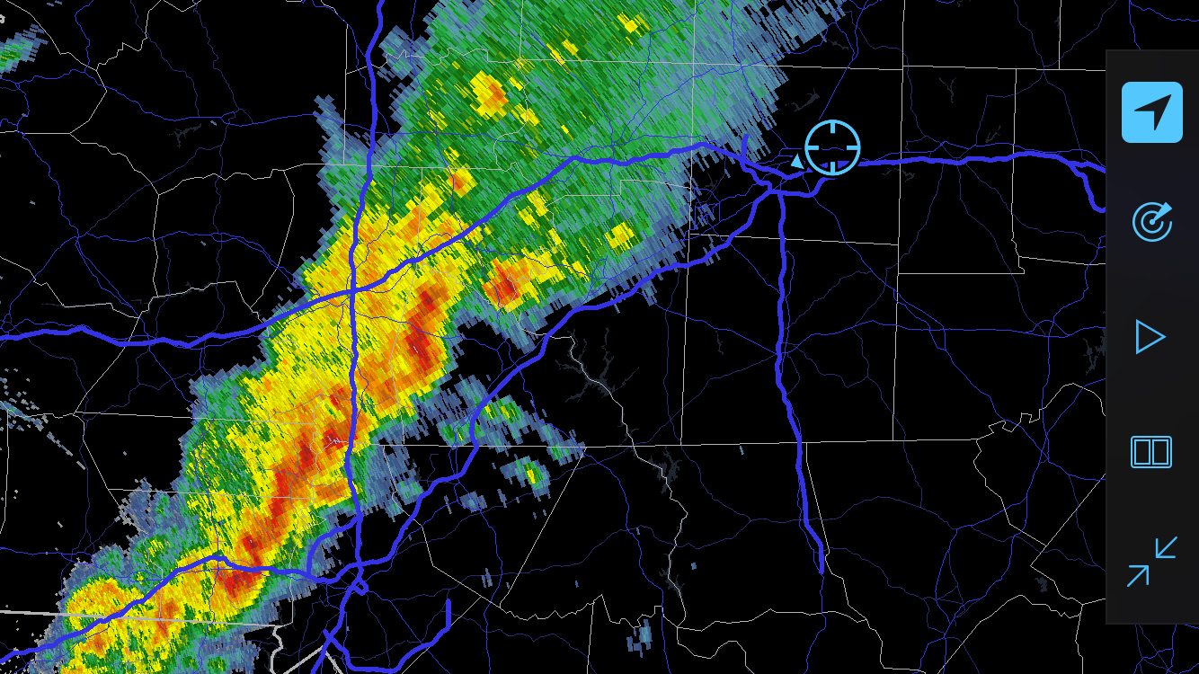
Our position at 4:45pm just northeast of Greensboro (above).
Near 5pm, we noted that the cell with the most mature presentation on radar was exhibiting a velocity couplet on radar (which was being sampled from Blacksburg's KFCX radar site). A few minutes after this a tornado warning was issued, and we were in perfect position within the polygon. We waited atop an overpass as the cell approached and the rotation intensified.

A NWS survey team later confirmed that a weak, rain wrapped tornado touched down in the city of High Point at about this time, damaging a few homes and paralleling the interstate.
We didn't want to get trapped in city traffic, so we stayed on the overpass with a very quick way to get on the highway immediately next to us. At this time (5:15 or so) the inflow feeding flow became visible with a rapidly moving stream of clouds.

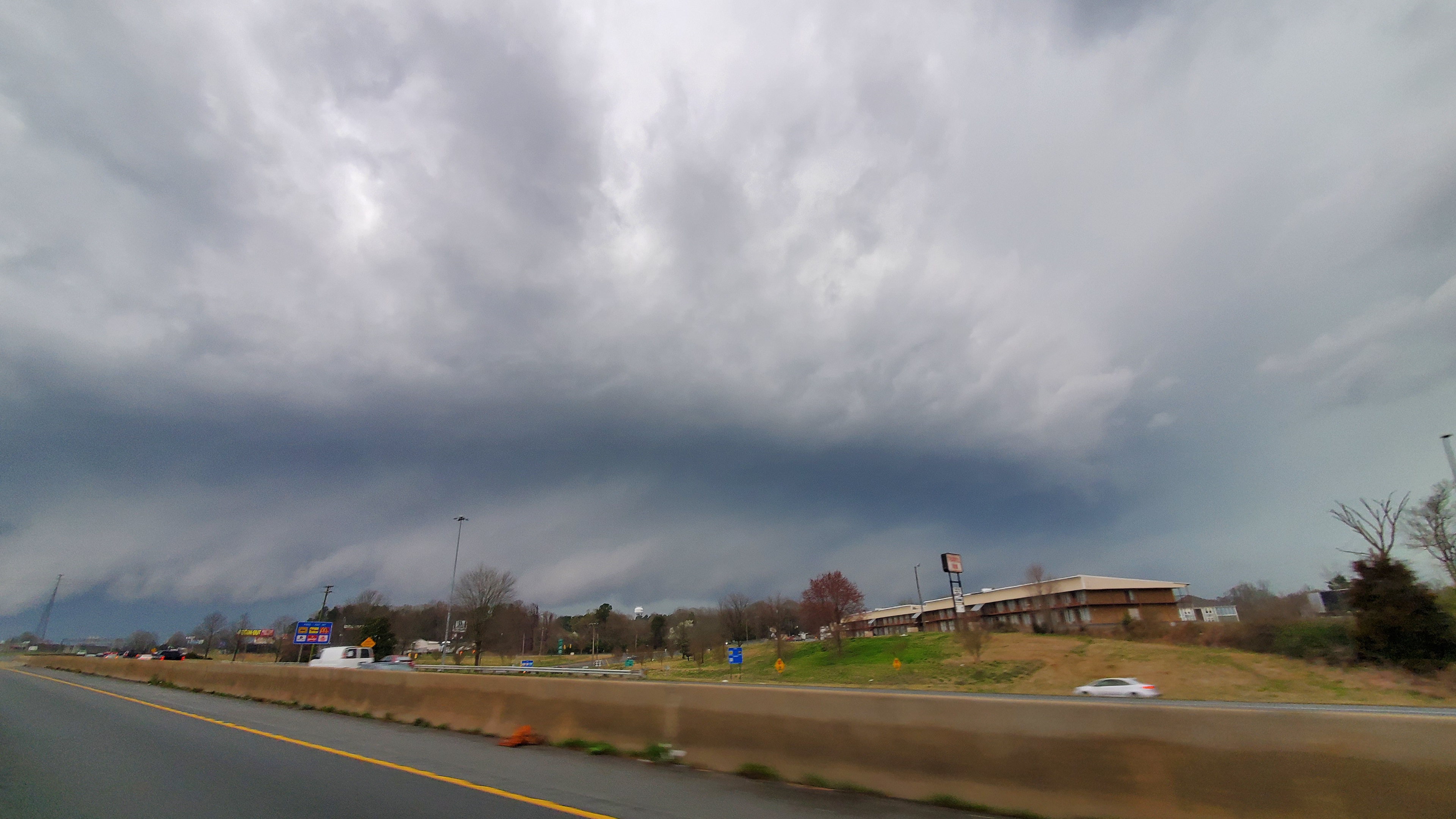
Although the inflow was not visually dramatic (photo above), it was impressive to watch as the moisture streamed right to left into the storm.
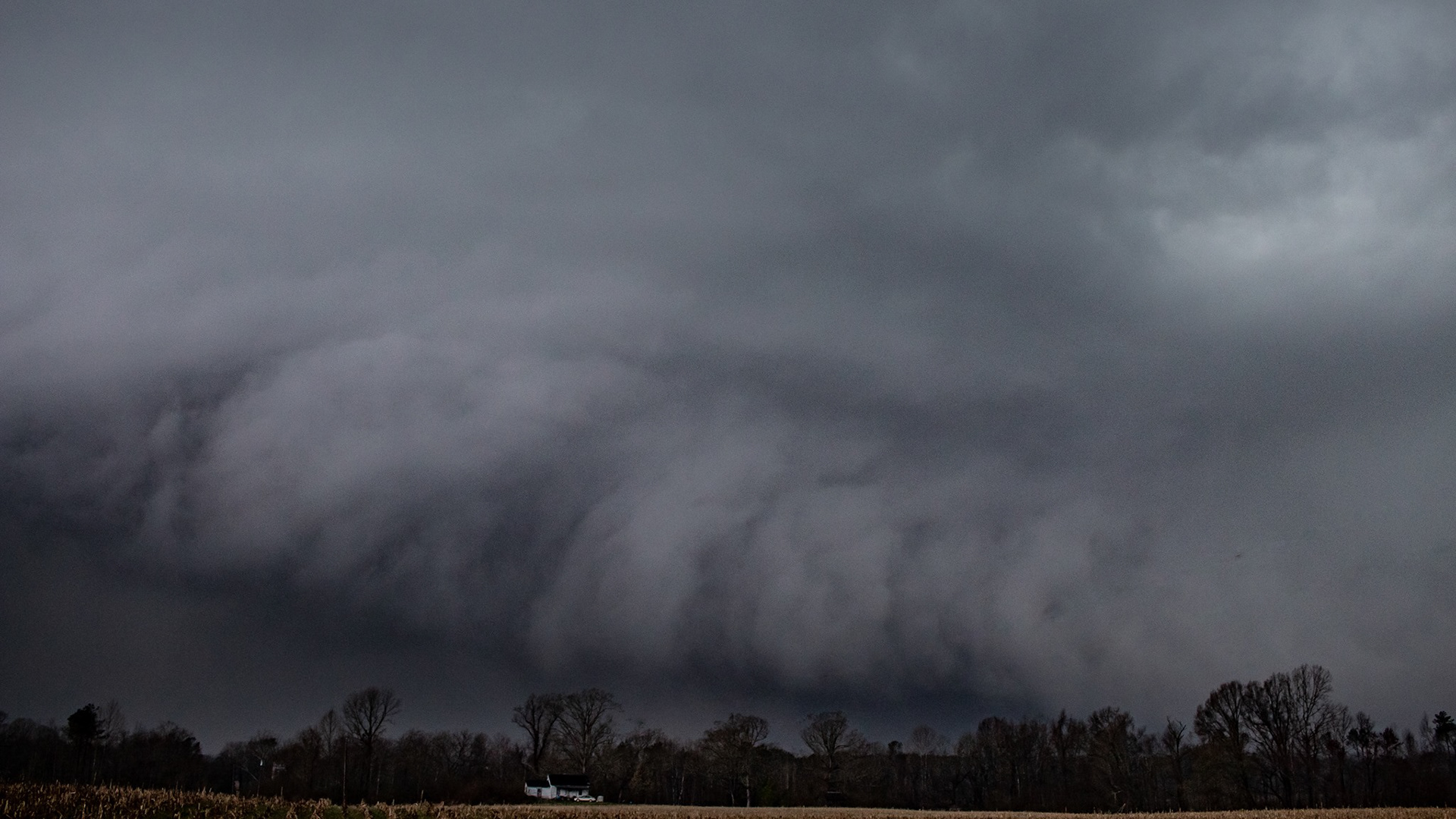
After watching the inflow for some time, the main rain core of the cell approached and we decided it was time to make our move to get closer to the circulation. We dropped south to I-40 and bounced from exit to exit (eastbound) as the circulation approached. The wall cloud showed itself at 5:30. This was from a new circulation on the south side of the mesocyclone, and was associated with a lightning spike. We stopped in the town of Whitsett and watched as the circulation passed less than 1/2 mile to our west at 5:45 pm.

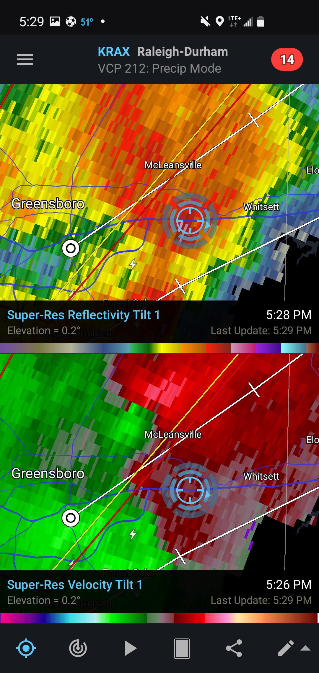
First view of the RFD shelf at approximately 5:25 pm (above). The inflow feeder visible in the lower left of the photo was quickly developing into a new area of rotation. The original couplet near McLeansville (visible in the above radar screenshot) was completely rain wrapped.

The wall cloud (above image, lower center) as it passed over Whitsett less than 1/2 mile to our west. Note the inflow tail developing on the lower right side, and the intense RFD showing itself on the left. The RFD shelf extended far to the left of this.
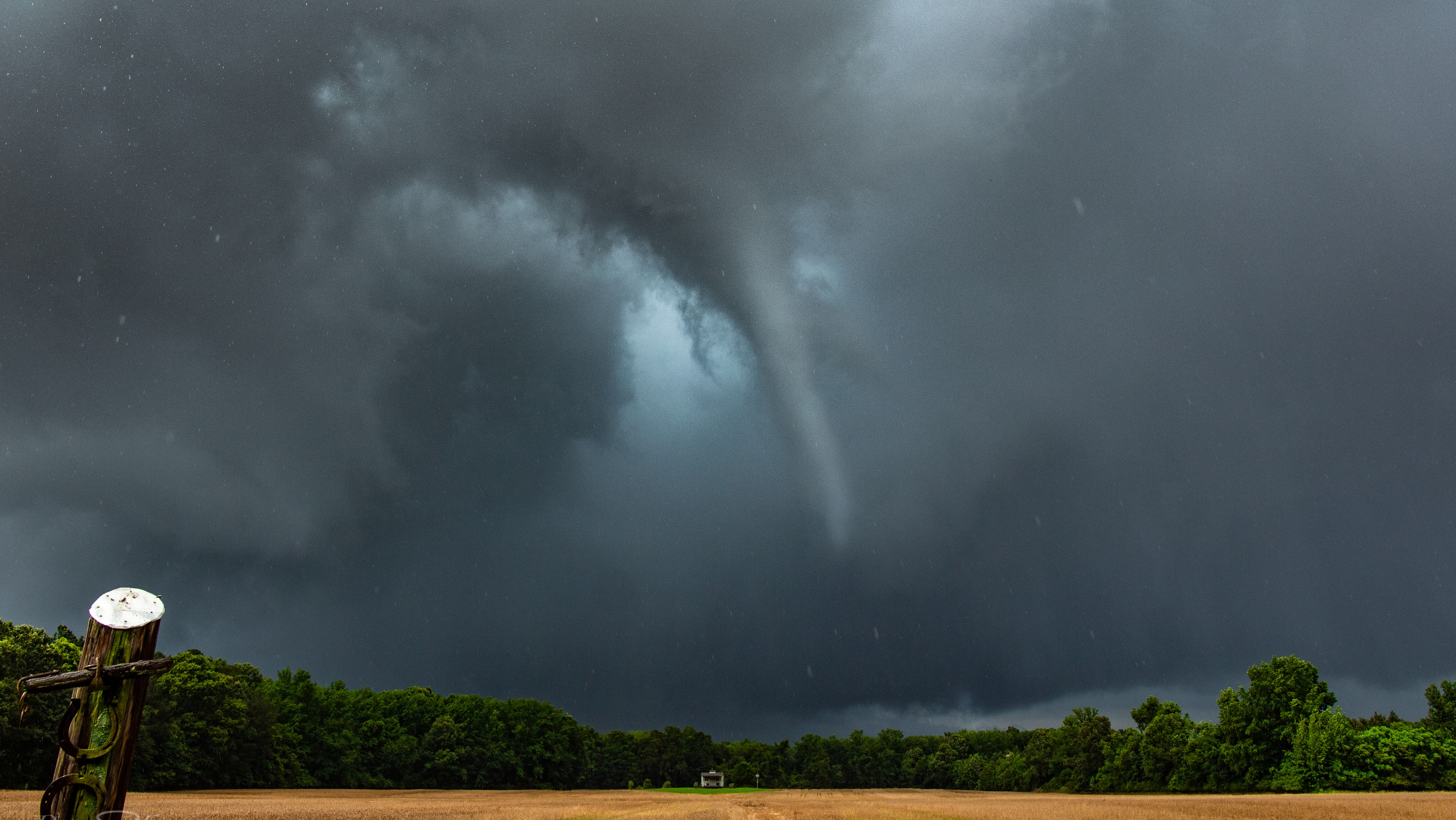
A NWS survey team later confirmed an EF-1 tornado touched down in Whitsett at 5:38 pm and lasted till 5:43 pm. We were positioned looking at the storm during this time, and captured the tornado in photographs. Although rain wrapped, contrast enhancement clearly shows the funnel. It counts as our first tornado of 2021! Fortunately it did minor damage and did not injure anybody.
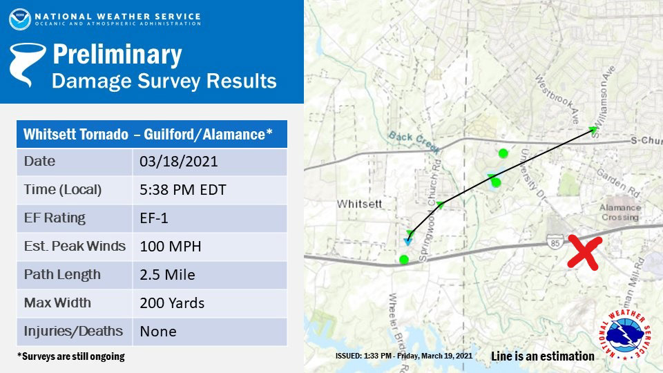
NWS survey results (above). The red x marks our location at 5:40 pm.

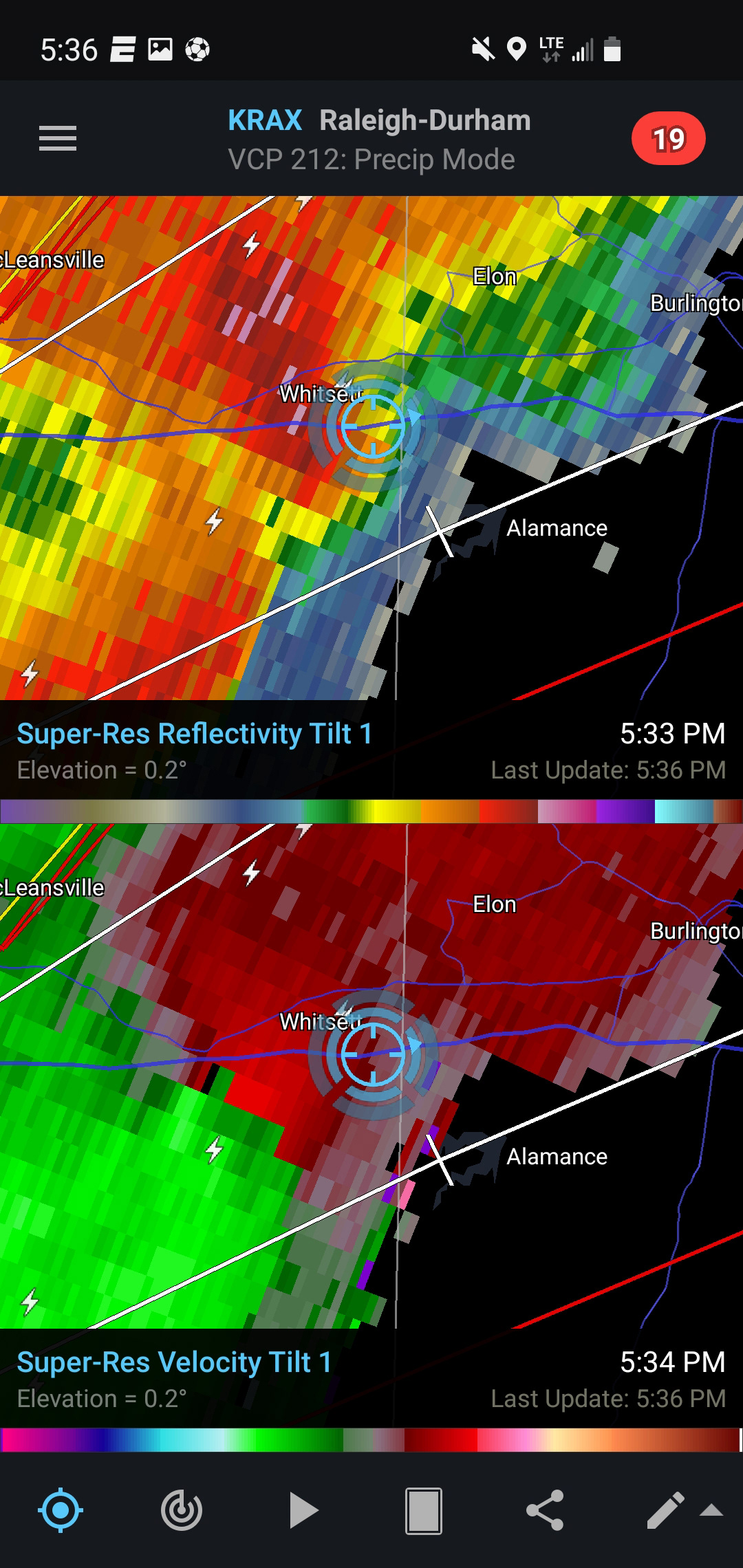
Contrast enhanced photo taken at 5:40 pm clearly shows the tornadic funnel. Although no scan exists for exactly 5:40 pm, the radar from a few minutes before clearly shows a hook echo and very strong couplet.

Wider shot which shows the tornado and the associated wall cloud, inflow tail, and RFD surge. A very grungy storm, but quite impressive.
At the time of the tornado, we had warm inflow at our backs which we estimated to be at least 25 mph. The RFD surge plastered us with strong wind and hail (which we estimate was about penny sized - but we did not have time to measure in our quick escape east).
After the tornado, we pushed east on I-40 to get some distance between us and the storm. The circulation was north of the interstate by this time which made our options to get closer very limited. We took photos out the side view and back windows for the next half hour and were treated to awesome deep mesocyclone structure (photo below - credit to Isaiah Parr on I-40 eastbound).
Several attempts were made to find a north route off of I-40 in order to get close to the rotation again. However, several towns and very slow traffic impeded our progress, and we had to bail on north routes two separate times. The storm produced another confirmed tornado at this time (approximately 6:04 pm), but we were unable to see it.
Fotrunately the interstate system became more favorable as we progressed east. I-85 takes a jog to the northeast on the north side or Durham, NC, so we decided to stick to the highway until we got to the town of Oxford. This gave us good distance ahead of the storm (which was still tornado warned) and allowed us to get a few miles north on Route 15. We found a field at 7pm and waited as the still strong mesocyclone approached our position from the east.
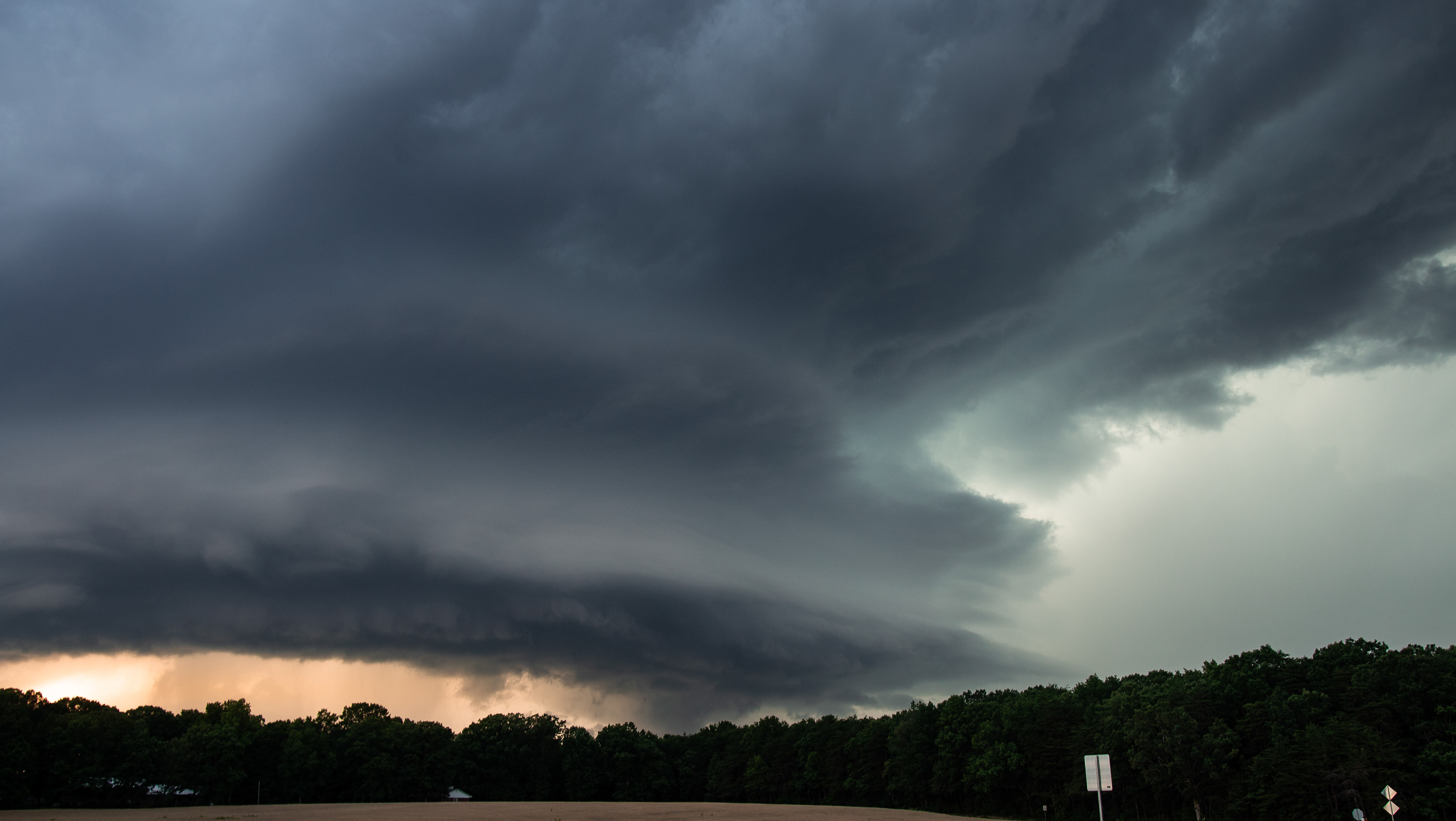
What followed for the next 15 minutes was a spectacular display of HP supercell structure, and rapid vertical and horizontal motion along the wall cloud. This ragged wall cloud could even be considered a collar cloud, a scuddy sleeve of rapidly ingested cloud that forms around an area of very strong circulation.

The wall cloud (center) at 7:00 pm. Photo (above) credit Peter Forister.
Close up view of the wall cloud/collar cloud at 7:05 pm. Photo (above) credit Mark Overbeck.

The final (and best) view of the collar cloud at approximately 7:10 pm.
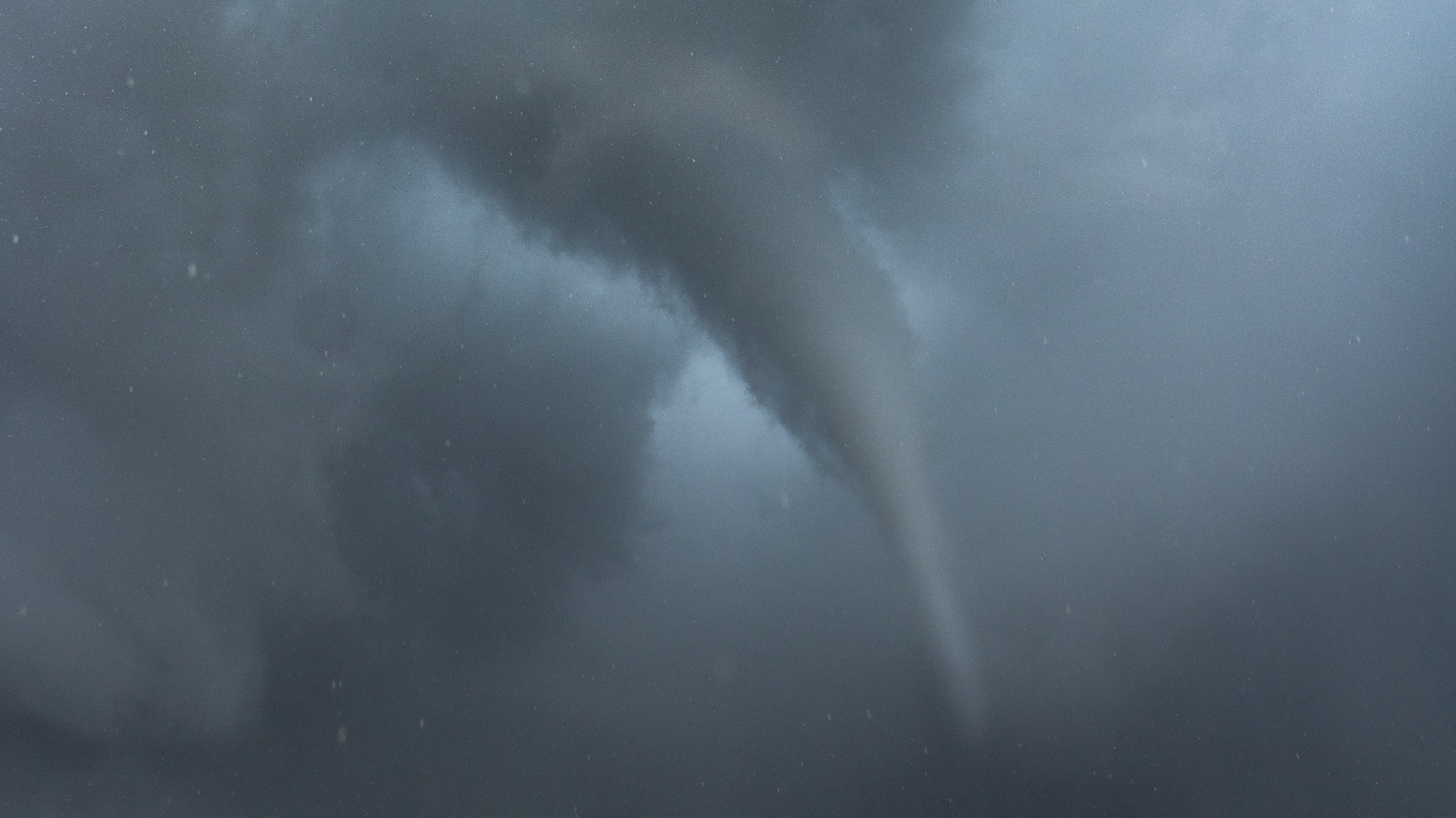
Shortly after the wall cloud passed just to our north, a dark shape in the inflow region revealed itself briefly. This wedge shape had extremely rapid motion associated with it and looked very much like a tornado to us at the time. Photographs also confirm that the structure was ground-scraping and featured structure that is to be expected with a tornadic circulation, with an RFD clearing out a slot behind it and a stout vertical edge on the left side.
Because this was never surveyed by the NWS (due to insufficient damage reports in the area) we called it a "possible tornado." Judge for yourself.

After this passed to the north we got hit very hard by a strong RFD with high winds and torrential rain. The sunlight was waning by this time, so darkness quickly set in. We made it back to I-85 and made one more push to get ahead of the storm. However, the mesocyclone continued to show a very tight couplet and we were greeted with an ominous presentation of a massive wall cloud and extremely dark skies. The unanimous decision was made that it was too dangerous to press on and risk getting caught up in the tornadic circulation on the highway, so we pulled off and let the RFD run us over in a safely parked location.
The chase concluded at 8pm just southeast of Norlina, NC. We had been under continuous tornado warnings for nearly three hours. The long drive back to our various homes in Virginia took place under anvil crawler lightning.


The view and radar presentation (both above) that led us to decide to pull off the chase. Intercepting a rain wrapped tornadic circulation in thick forests and darkness did not seem like a smart thing to continue pursuing!