2020 Storm Chase Highlights
Year in review
By Peter Forister
Despite the challenges of 2020, this year was incredibly productive for storms around the Mid-Atlantic, and one of my most successful years chasing locally. This is a non-chronological review of some of the best storm days, which included tornadoes, hurricanes, winter storms, and other remarkable meteorological phenomena.
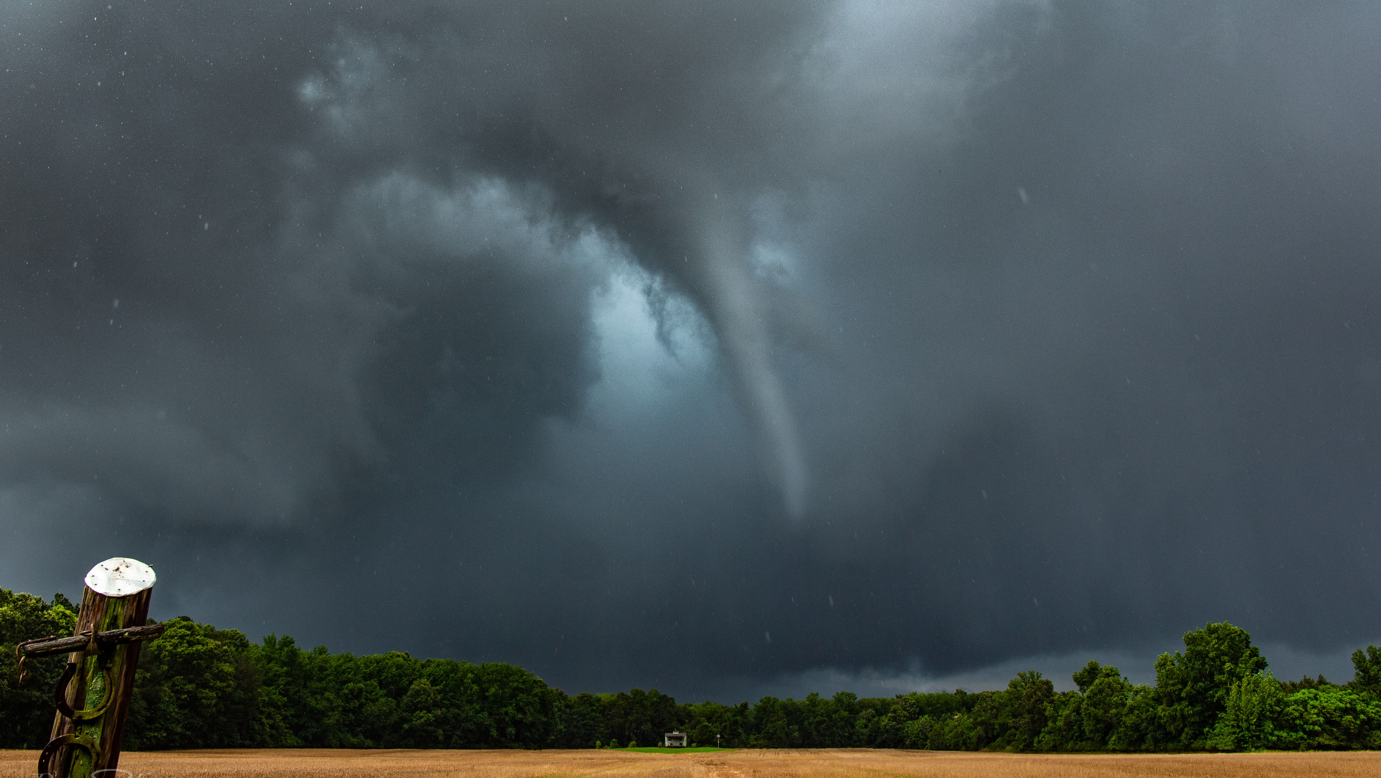
#1: Tornado in Conway, North Carolina
June 17

This "surprise" tornado occurred on a marginal risk day in far northeastern North Carolina. A hunch (based on helicity and cape values) told us to drive to this setup, and some careful positioning behind the storm gave us this spectacular view of a tube. This is a storm chaser's dream - to see a picturesque tornado without any significant damage to life or property. This photo was snapped in the rope-out stage of the tornado.
Read about the full storm chase, our decision making, and full photo album from this storm here: CONWAY TORNADO BLOG POST
Also watch my videos from the storm on YouTube:
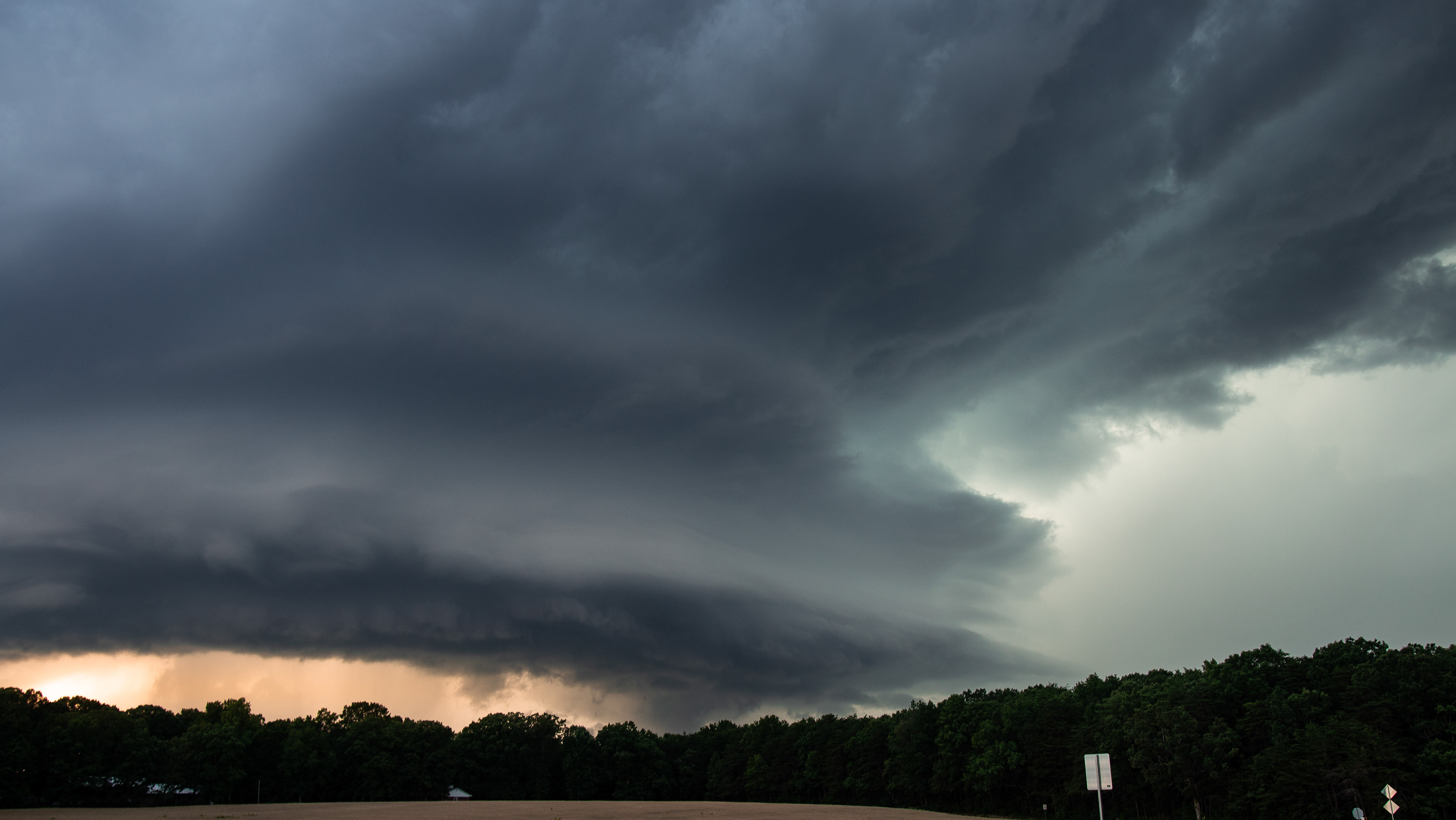
#2: HP Supercell in central Virginia
June 25


This beast of a storm travelled hundreds of miles from the Blue Ridge Mountains to the Chesapeake bay, and was a visual treat to chase. At its most intense, this supercell featured some of the best mesocyclone and RFD shelf cloud structure I've ever seen on a Mid-Atlantic storm.
Read the full blog post about this storm chase, including the synoptic setup and full photo album here: SUPERCELL BLOG POST
Watch my presentation about this storm from the Mid-Atlantic Chaser Convention:
#3: LP Supercell in Luray, Virginia
August 1


This storm was a part of a well forecasted severe weather outbreak in Virginia, but still came as a surprise due to the visual quality of the storm structure. The low-precipitation supercell passed over some of the highest terrain in the state, and maintained its structural integrity and physical appearance through the mountains. It produced several funnel clouds near the mountain town of Luray.
For this chase, I positioned on interstate 81 and waited for the storm cell to approach me. I pulled a hook slice maneuver near the town of Woodstock and came out by a rapidly rotating wall cloud (another chaser claims there was a tornado at this point, but I never saw ground contact). After watching the storm cross the narrow valley from the inflow region, I cut across the next mountain ridge and saw the same structure again in the Shenandoah valley from a distance. The golden fields of wheat and the backdrop of Shenandoah National Park made this quite the spectacle.
#4: Tornado in Tropical Storm Isaias
August 4

Tropical Storm Isaias was a significant tornado producing system across the Mid-Atlantic, generating tornadoes from North Carolina to New England. We were positioned in Ocean City, Maryland to catch the outer supercell bands during daylight, and intercepted a quick-moving tornado. Although ugly, this tornado remained on the ground for 10 miles.
Watch the full video from the tropical storm and tornado chase:
#5: Shelf Cloud/SLC. Charlottesville, Virginia
June 10


Yes, a shelf cloud made this list! This was a relatively low-key summer thunderstorm day, but briefly produced this crazy storm structure as it passed over downtown Charlottesville. I love ground-scraping structure, and this shelf had it all. Vertical fingers of condensation lifted up from the treetops and created convective bubbles thousands of feet tall. Very weak circulations were visible at the surface, making me think that there could have been a couple gustnadoes as well. Classic "Scary looking cloud" structure from a harmless storm.
#6: Tornado in Charlottesville, Virginia
August 6

Another low-risk severe thunderstorm day which ended up overproducing in Central Virginia! a messy storm complex fired up over Harrisonburg, and quickly went tornado-warned as it crossed over the Blue Ridge Mountains. The southern edge of the complex maintained rotation (and some huge hail) as it approached the CHO airport where I was waiting.
The positioning near the airport on high ground let me get a view of a tornado as it touched down about a mile to my east. This was another messy storm with an ugly tornado, but it counts as my third of the year.
#7: LP Supercell Madison, Virginia
May 22


This storm was a classic representation of "Route 29 magic" and was my first impressive supercell intercept of the year. This was a small storm that fired over the Blue Ridge Mountains, and as it moved east onto flatter terrain, it picked up strong mid-level rotation and spectacular wall cloud and mesocyclone structure. It moved at less than 10 miles per hour, so I easily watched it for a couple hours. It was also my first successful intercept of a storm with drone images.
#8: Midnight Supercell Amherst, Virginia
April 7


An extremely long-lived supercell started in Ohio and travelled all the way across West Virginia and the high mountains of western Virginia, complete with a string of tornado warnings and hail reports. I was watching the storm on radar for hours and fully expected it to dissipate, but as midnight approached, it became clear that nocturnal instability values would allow it to survive to a chaseable region.
I intercepted the storm just north of Amherst, VA where the storm structure was only illuminated by lightning. Although not the most impressive storm I saw this year, it was quite an experience punching and photographing this cell with the stars as a backdrop.
#9: Ice Storm in Albemarle County, Virginia
December 16

A large nor'easter storm system in the middle of December was primarily a snowmaker in New England, but Central Virginia was in the goldilocks zone for sub-freezing temps and an entire day of rainfall. Areas like Charlottesville saw 0.25" of ice accretion, but slightly higher elevations to the east saw ice accumulations up to an inch. This was the most ice accumulation I've ever seen.
The storm knocked out power for tens of thousands of people in the region and caused widespread tree damage. The ice created some amazing photograph opportunities.
#10: Supercell and hailstorm Danville, Virginia
April 8


Another long lived supercell fired in West Virginia and travelled east to the Piedmont of Virginia. Although tornado warned, the primary threat from this storm ended up being hail. The storm produced a swath of hail from near Rocky Mount to north side of Danville, while I followed it the entire way.
The RFD shelf cloud structure had some very nice greenage associated with the heaviest hail core. A very nice chase for an early-season low CAPE setup.
Thank you for reading! If you enjoyed, please check out my social media and consider supporting my work though my photography store - many of these photos are available for printing.