Tornado in North Carolina
June 17, 2020
Photos by Peter Forister and Andrew Shearer
What started as a marginal outlook with high uncertainty of even seeing a storm turned into one of the most picturesque tornadoes we've seen in the Mid-Atlantic. We've seen other tornadoes here, but most are ragged, wrapped in rain, or moving at 70+ mph embedded in a linear system. This day turned into a remarkably simple event in comparison. This is our chase overview of the event, but first here's a quick definition:
Historically, the vast majority of tornadoes around the region are produced by tropical cyclone remnants or QLCS (primarily linear storm complexes) which lead to low visibility and extremely difficult chasing conditions. However, there is an extra element that can help produce tornadoes on the "off" days: LCL heights.
"LCL" stands for the "Lifted condensation layer" and represents the bottom of the cloud base. This layer is why cumulus clouds are puffy on top and flat on the bottom. Effectively, the lower the base of the cloud, the higher probability that any supercellular rotation can be translated into a ground-touching tornadic vortex. It's just less distance for that energy to travel which makes it easier.
Now for the storm chase. We (Peter and Drew) noticed the setup about 36 hours before the event showing up on the high-resolution models. A *very* small region of high CAPE (3000-4000 j/kg) was showing up in far northeastern North Carolina. While this amount of cape is not unusual in that part of the state in the summer, the shear that went along with it was unusual. A weak tropical system was moving north (it was only marked as an "Invest" by the NHC) and brought some low level shear with it.

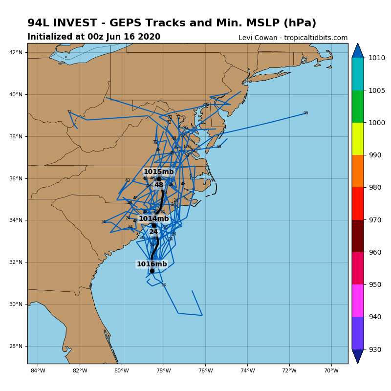
Invest 94L tracking north into North Carolina on the morning of June 17
This small region of CAPE and shear overlap was highlighted by the EHI parameter on the Nam3k nicely.
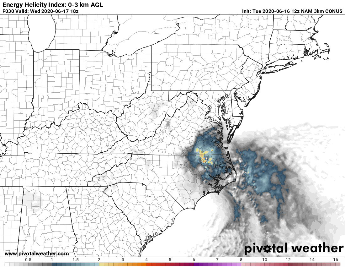
Energy Helicity Intex
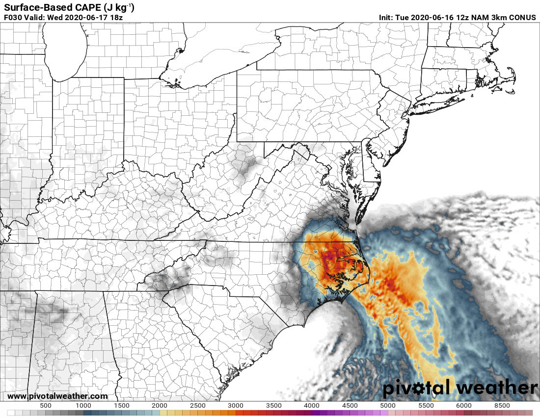
Surface Based CAPE

Storm Relative Helicity
We've all seen this kind of setup bust before though. The most uncertain part of the forecast was the CAPE, which could have been easily busted due to cloud cover or a poor moisture fetch. With this in mind, the Storm Prediction Center didn't even outline a severe thunderstorm risk for the area at all.
Despite the high uncertainty, there was a "tingle" in the air that we just couldn't pass up. We had never driven hundreds of miles for a sub-severe setup before, but this was just too juicy to pass up. We drove to Emporia, Virginia to be in position by the time storms fired up around lunchtime.
When we arrived in Emporia, the SPC updated the severe risk and included a 2% risk area for tornadoes! The CAPE was going crazy too, with over 3500 observed. The surface analysis also noted due easterly surface winds.
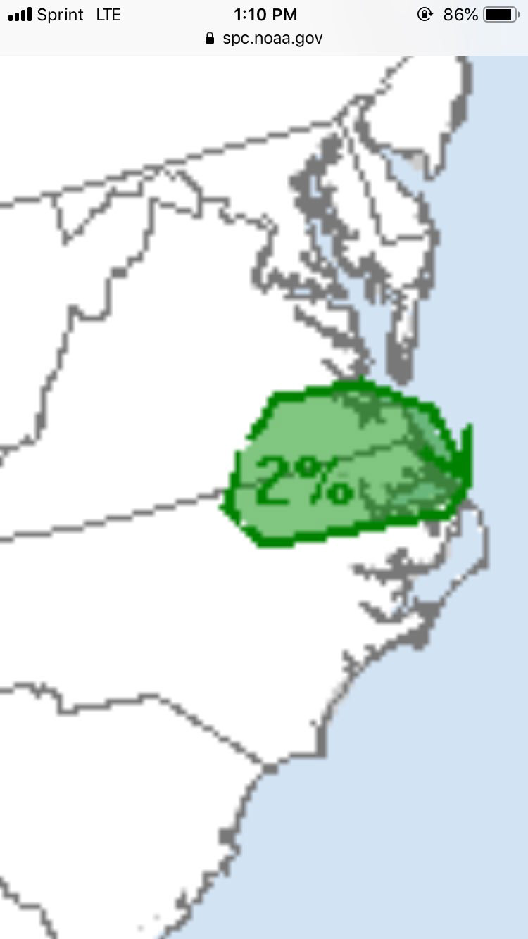
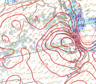
SPC update to 2% and the CAPE levels per RAP Mesoanalysis
The chase was on!
We positioned a bit further south from Emporia to target three thunderstorms that had fired to the south. All three of these storms quickly took on supercell characteristics with marginal rotation and hook echoes. We found a view of the western cell and noted that the LCLs were exceptionally low - perhaps only 200-300 feet off the ground.
The cell fizzled out near Roanoke Rapids as it drifted out of the high CAPE area, but we had more targets to the east.

The ground-scraping LCLs

We drove east to the small town of Conway, NC. The center of the three cells was starting to look stronger, with a notable lightning spike and a crisp precipitation core. We caught brief glimpses of the base while driving east, but the LCLs were so low that basically any trees on the horizon blocked our view. Once in Conway, we drove south of out of town right into the inflow notch of the storm.
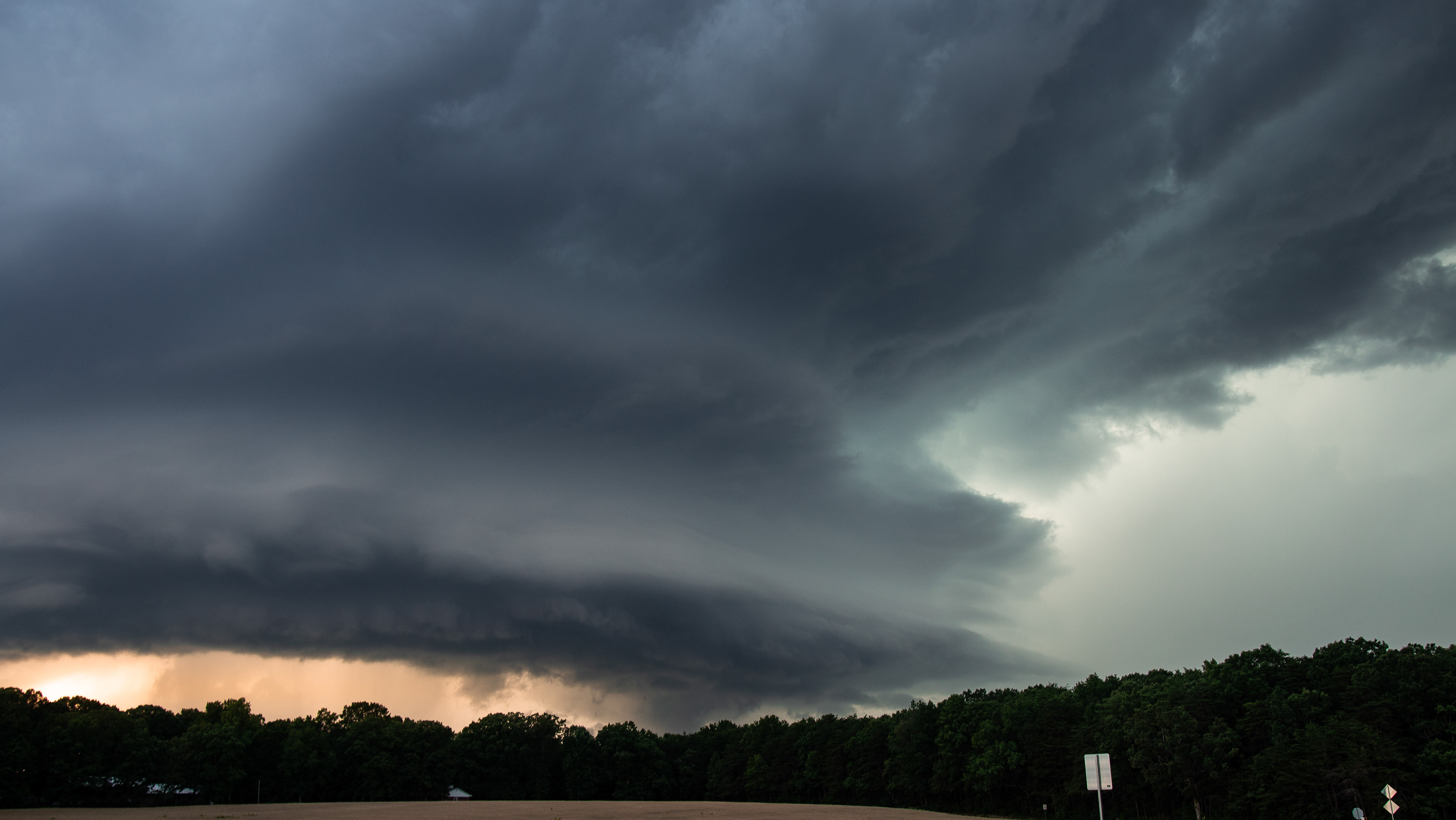
After driving about two miles south, we were met with a large mesocyclone and rapidly rotating wall cloud at 3:20pm. Both had classic structure features.

Mesocyclone, wall cloud, and inflow tail.

We sat in this field for a few moments watching the wall cloud rotate. It was moving very slowly towards our location. We sent a rotating wall cloud report to the NWS from this location, and started recording video a couple minutes later.
Suddenly in the video, we noticed an area of extreme vertical motion immediately behind the wall cloud. This condensed into a ragged funnel cloud with obvious tight rotation at 3:35pm. It was slightly obscured by a line of trees, but we noted some small debris being lofted at about 3:36pm, and called it a tornado at this point.
The following three pictures show our views at 3:33, 3:35, and 3:36pm:

3:33pm: low wall cloud with possible funnel cloud behind it obscured by the tall tree

3:35pm: funnel cloud with rapidly rising motion. This is a "scud tag" look.

3:36pm: Better condensed funnel. Small debris being lofted at this point - so we called it a tornado.
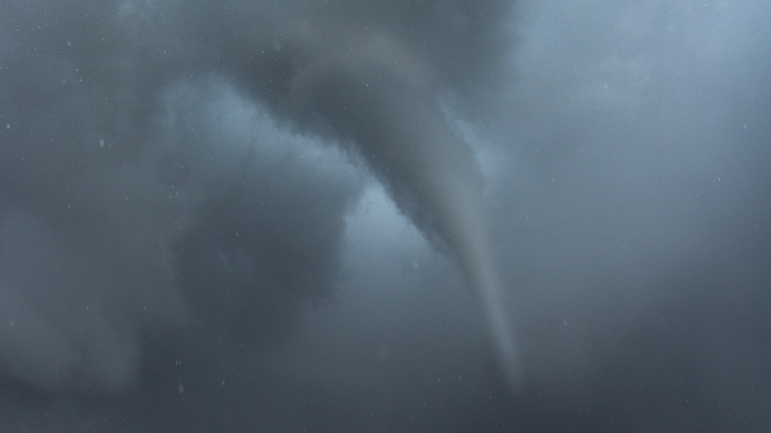
At this point, we noticed that the area of strongest rotation/tornado seemed to be moving straight at us. We drove south about half a mile to get out of the immediate path. Once clear, we pulled a U-turn and pointed directly at the tornado. By this time, it was fully condensed and small debris was falling out of the sky. We were able to record video while slowly driving down the road towards it at 3:38 - 3:40pm.

The fully-condensed tornado
We noted a field just down a side road to the left, so we pulled into it and got our best unobstructed view of the funnel. However, by this time (3:40 pm) the condensation funnel lifted off the ground and probably was not making contact with the surface anymore.
What followed was some of the best storm structure we've seen in this part of the country with a clearly visible laminar funnel back-lit by the sun. It was simply spectacular! We were no more than 1/4 of a mile from the funnel at this point, but in a perfectly safe location as the circulation drifted slowly north.


After this point, the funnel dissipated. We estimated that the tornado was on the ground for about five minutes, and the funnel persisted for about 10. No damage was ever found (fortunately!) because it was most likely very weak at the surface and only took leaves and small branches off trees.
The storm continued to produce brief funnel clouds. We were never close enough to confirm any ground circulations, but the storm continued to spin for the next half hour before slowly drifting north out of the high CAPE.


In all, we counted at least 5 individual funnel clouds over the next half hour. The storm remained tornado-warned (based on our reporting) through this period.
What an amazing experience! This is why we chase!